| English
--> engfpages-000
--> engfpages-f1026-5 |
Same
CN |
|
|
|
engmus-f1026-5
|
|
A
trip in west America of my German long friend Mr. Chilian
|
|
Four
Corners / Monument Valley
|
|
|
|
|
|
Morricone
soundtracks resource library (Total
5596 tracks)
has been opened, Free download
>>>>>>
|
|
|
|
The editor's word:
Mr. Chilian is my German long friend for philately. I have
introduced his brief
features here,
and his story have been published in our philatelic
web site . This year, Mr.Chilian and his wife Maria
revisit the old haunt--America. But there are two point
in this trip: one is driving a car as himself; Other one
is in western America, especially Arizona and Grand Canyon.
He sent many rare photos for us, It is very valuable for
Morricone's Fans who are interested in the Spaghetti
Westerns very much. So we publish
these photos below for share (Mr.Chilian's
more pages : 00,
01,
02,
03,
04,
05,
06,
07,
08,
09,
10,
11,
12,
13
...)
|
|
|
|
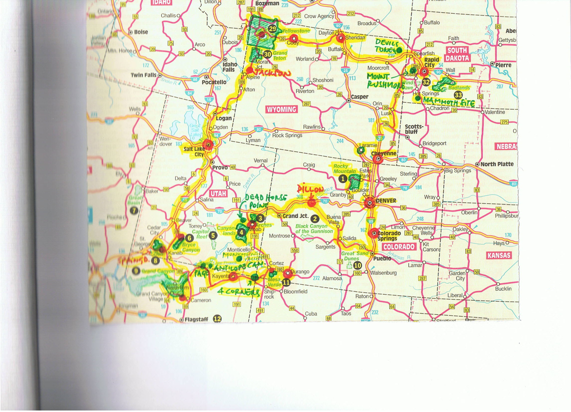
001-
A route map of Mr.Chilian's trip of western America
|
|
Mr. Chilian said in an E-mail: "attached
is a map showing our trip. We started in Denver drove up
north to Mt. Rushmore, than west to Yellowstone NP, south
to Salt Lake City to Grand Canyon. From there we drove east
along all the canyons back to Denver."
|
|
|
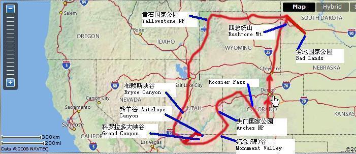
| For the
sake of more clearly understand this route , I made
a new map by way of Yahoo site below: Red is route of
the trip, white frame and blue line are main landscapes. |
|
|
|
|
|
|
|
002
An explaination
|
| |
| Mr. Chilian sent total 102
photos, every file's size is about 5M and 8 million PX. The size is
too much for web page, so we have to select 65 photos and properly
compress them, but still more than 2 million PX. You can click every
photo for see bigger photo. Mr. Chilian also wrote explanation for
every photo. We added some note in some photos so that you could understand
more |
|
|
|
IP1709-44
|
| Four Corners. 4 states
- Utah, Colorado, Arizona and New Mexico - meet at one
point. |
|
|
|
|
| Note:
The Four Corners Monument marks the quadripoint in the Navajo
Nation and Ute Mountain Tribal Lands in the Southwest United
States where the states of Arizona, Colorado, New Mexico and
Utah meet ― the only point in the United States where the
boundaries of four states intersect.
It is located on the Colorado Plateau west
of U.S. Highway 160, 40 miles southwest of Cortez, Colorado.
It is centered at 36°59′56.31532″N 109°02′42.62019″W? /
?36.9989764778, -109.045172275.[1] The point was originally
declared by Congress to be 37°N, 109°W, but an early surveying
error misplaced the location. The US Supreme Court later
ruled that the current location had become so standard that
it should be officially recognized as the actual boundary
between the four states.
Not only is the point a perpendicular corner
intersection, it is the only point in the United States
shared by four states, leading to their being called the
Four Corners region. A Ute Indian reservation abuts the
point in Colorado. The landmark is run by the Navajo Nation
Parks and Recreation Department and is a popular tourist
attraction, despite its isolated and somewhat remote location.
An admission fee is required to view and photograph the
monument.
Around the monument, local Navajo and Ute
artisans sell souvenirs and food. The position of the point
was initially surveyed by E. N. Darling in 1868, and marked
with a sandstone marker.[2] The first permanent marker at
the point was placed in 1912. It was replaced in 1992 with
a granite marker embedded with a large circular bronze disk
around the point, surrounded by smaller, appropriately located
state seals and flags.(See here)
|
|
|
IP1709-045
|
| Indian chief Geronimo
on US flag |
| |
|
|
|
|
|
IP1709-092
|
| Monument
Valley. We call it Malboro Country (from the cigarette
TV advertisement) |
|
|
|
|
|
|
IP1709-089,
090, 091
|
| Monument Valley is on
Navajo Indian Reservation. All fotos were shot at sunset.
|
|
|
|
|
|
|
|
|
|
|
Note:
The Navajo Nation (Diné Bikéyah in
the Navajo language) is a semi-autonomous Native American
homeland covering about 26,000 square miles (67,339 square
kilometres, 17 million acres), occupying all of northeastern
Arizona, the southeast portion of Utah, and northwestern
New Mexico. It is the largest land area assigned primarily
to a Native American jurisdiction within the United States.
The Nation encompasses the land, kinship,
language, religion, and the right of its people to govern
themselves. Members of the Nation are often known as Navajo
(or Navaho) but traditionally call themselves Diné (sometimes
spelled in English as Dineh) which means the people.
The 2000 census reported 298,215 Navajo
people living throughout the United States, of which 173,987
were within the Navajo Nation boundaries. Of these, 131,166
lived in Arizona (17,512 in Maricopa County, which includes
the city of Phoenix).
Because the Navajo Nation includes land
in three states, its Division of Economic Development compiles
census data for the Navajo Nation as a whole. Another group
lives on the Colorado River Indian Tribes reservation along
the Colorado River in California and Arizona.(See here)
The Navajo Indian Reservation (Navajo Country), established
in 1868, is the largest Indian reservation in the United
States. Lying for the most part in Arizona, it is bounded
on the west by the Colorado River and on the north by Lake
Powell, a long artificial lake formed in a canyon, and the
San Juan River; the boundaries on the east and south are
ruler straight. Much of the central part of the territory,
roughly half of which is barren and infertile, is a desertic
tableland slashed by canyons. To the east, striking north-south,
are the Chuska Mountains, with Pastora Peak (9,413ft/2,869m);
to the northeast is the Ute Mountain
... More >
Indian Reservation in Colorado; and to the southwest is
the Hopi Indian Reservation, which has an area of some 560sq.mi/1,450sq.km.
The most interesting parts of Navajo Country, both scenically
and culturally, are organized and protected as Tribal Parks
or National Monuments. The largest settlements in the reservation
are Window Rock (Navajo), the Indian-run administrative
center of the reservation, and Hotevilla(See here)
---------------------------------------------
The
movie "Navajo Joe"composed
by Ennio Morricone(as Leo Nichols)(Director Sergio
Corbucci) >>>>
|
The
OST of the movie "Navajo
Joe" >>>>
|
|
|
|
The
stamps mailed by Mr. Chilian-05
Grand Canyon / Monument Valley
|
|
|
|
|
IP1709-043
|
| Maria collecting red sand
at Monument valley. |
|
|
|
|
Note:
Monument Valley is located on the southern border of Utah
with northern Arizona (around 36°59′N 110°6′W? / ?36.983,
-110.1). The valley lies within the range of the Navajo Nation
Reservation, and is accessible from U.S. Highway 163. The
Navajo name for the valley is Tsé Bii' Ndzisgaii (Valley of
the Rocks). (See here)
The Navajo Indian Reservation (Navajo Country),
established in 1868, is the largest Indian reservation in
the United States. Lying for the most part in Arizona, it
is bounded on the west by the Colorado River and on the north
by Lake Powell, a long artificial lake formed in a canyon,
and the San Juan River; the boundaries on the east and south
are ruler straight. Much of the central part of the territory,
roughly half of which is barren and infertile, is a desertic
tableland slashed by canyons. To the east, striking north-south,
are the Chuska Mountains, with Pastora Peak (9,413ft/2,869m);
to the northeast is the Ute Mountain
... More >
Indian Reservation in Colorado; and to the southwest is the
Hopi Indian Reservation, which has an area of some 560sq.mi/1,450sq.km.
The most interesting parts of Navajo Country, both scenically
and culturally, are organized and protected as Tribal Parks
or National Monuments. The largest settlements in the reservation
are Window Rock (Navajo), the Indian-run administrative center
of the reservation, and Hotevilla (See here) |
|
|
|
| |
|
|
| |
|
|
|
Nov.10, 2008
|
|
|
|
|
|
|
|
|
|